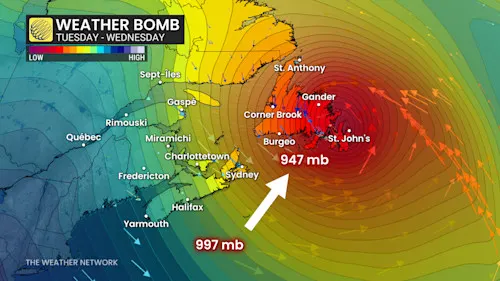
Eastern Canada is under threat as a rapidly intensifying weather system, termed a “weather bomb”, sweeps across Newfoundland, Nova Scotia, and New Brunswick. The storm is producing very high winds, heavy rainfall, and coastal flooding, prompting authorities to issue urgent safety warnings.
Rapid Intensification and Extreme Weather
Meteorologists report that the system strengthened quickly, experiencing a rapid drop in atmospheric pressure—a key characteristic of a weather bomb that can trigger extreme conditions over a short period. Residents are being urged to remain vigilant, particularly in low-lying coastal areas and along vulnerable transportation routes.
Impact on Transportation and Infrastructure
Officials have warned of road closures, ferry cancellations, and flight delays as strong winds and flooding affect mobility. Local emergency services are on high alert, ready to respond to power outages, fallen trees, and property damage caused by the severe storm.
Safety Precautions and Public Advisory
Authorities emphasize the importance of monitoring local weather advisories, securing outdoor objects, and avoiding travel during the storm’s peak. The weather bomb is expected to persist through the weekend, with some regions experiencing the heaviest impacts tonight.
Coordinated Response Efforts
Emergency management teams across the Atlantic provinces are coordinating efforts to mitigate damage and ensure public safety. Rapid changes in conditions mean that residents must remain cautious and prepared for hazardous weather and limited mobility.

