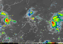
The Philippine Atmospheric, Geophysical and Astronomical Services Administration (PAGASA) has officially declared the formation of Tropical Depression Ramil over the western Pacific, prompting the issuance of Tropical Cyclone Wind Signal No. 1 across several parts of the country.
Ramil’s Position and Strength
As of Friday morning, Ramil was located east of Northern Luzon, carrying maximum sustained winds of 55 km/h near the center and gusts of up to 70 km/h. The system is moving west-northwest, with forecasters monitoring its potential to intensify into a tropical storm as it nears the Philippine landmass.
Rainfall and Flood Warnings
Light to moderate rains, with occasional heavy downpours, are expected in affected regions, including Cagayan Valley, Isabela, and parts of the Cordillera Administrative Region. PAGASA has warned residents in low-lying and mountainous areas to remain vigilant for possible flash floods and landslides.
“While Ramil remains a weak tropical depression, its slow movement and broad rainbands could bring significant rainfall over the next 48 hours,” PAGASA said in its latest advisory.
Sea Conditions and Safety Alerts
The weather bureau also cautioned fisherfolk and small sea vessels against venturing into the northern and eastern seaboards due to rough sea conditions. Local disaster management councils have been placed on heightened alert, preparing evacuation and relief measures in case the system intensifies.
Forecast Track and Next Developments
Meteorologists are tracking whether Ramil will follow a westward path toward Northern Luzon or recurve toward the East China Sea in the coming days. PAGASA will continue issuing updates as the storm evolves and potentially strengthens.
If Ramil intensifies into a tropical storm, it will become the 20th named cyclone to enter the Philippine Area of Responsibility (PAR) in 2025.

