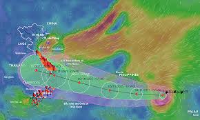
Typhoon Kalmaegi, locally known as Tino, has strengthened over the South China Sea and is now heading toward southern Vietnam, according to regional meteorological agencies. The storm is expected to make landfall late Tuesday or early Wednesday, bringing torrential rain, flash flooding, and damaging winds across coastal provinces.
Storm Intensifies Over the South China Sea
Vietnam’s National Center for Hydro-Meteorological Forecasting (NCHMF) reported that Kalmaegi has intensified into a Category 2 typhoon, with sustained winds reaching up to 150 km/h (93 mph) near its center. Authorities have issued storm warnings and evacuation advisories for residents in low-lying and coastal regions ahead of landfall.
“People should brace for widespread rainfall and possible landslides in mountainous regions,” the NCHMF said in a Monday evening update. “We urge fishermen and vessels to stay in port until the storm passes.”
Evacuations and Emergency Preparations Underway
The Vietnamese government has placed disaster response units on high alert, with schools in affected provinces ordered closed and emergency shelters being readied. Coastal communities have begun moving to higher ground as strong waves and heavy rain approach.
Neighboring countries, including Cambodia and Laos, are also monitoring the storm, which may weaken into a tropical system as it crosses Vietnam’s mainland later in the week.
Part of a Record Typhoon Season
Meteorologists note that Kalmaegi is the 18th named storm of the 2025 Pacific typhoon season, continuing a year marked by unusually high tropical cyclone activity fueled by warm ocean temperatures and shifting climate patterns.

