The World Meteorological Organization (WMO) has issued its seasonal climate outlook, forecasting the development of a weak La Niña event this fall. While less intense than previous episodes, this phenomenon is expected to influence rainfall and temperature patterns worldwide, with implications for agriculture, water management, and disaster preparedness.
Warmer Conditions in Northern Mid-Latitudes and Tropics
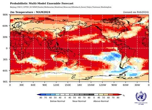
The WMO projects warmer-than-normal surface temperatures across much of the northern mid-latitudes, including parts of North America, Europe, and northern Asia. These elevated temperatures could intensify heatwaves, increase energy demand, and impact local ecosystems.
Equatorial regions, including parts of Africa, Southeast Asia, and the Maritime Continent, are also likely to experience above-average temperatures. Meteorologists warn that these warm conditions may exacerbate drought risks and affect seasonal crop cycles in vulnerable areas.
Shifts in Rainfall Patterns
La Niña typically alters tropical rainfall distribution. During this weak event, certain regions may see higher-than-average precipitation:
- Southeast Asia: Countries such as Indonesia, Thailand, and the Philippines may experience enhanced monsoon activity, increasing flood risks in low-lying areas.
- Eastern Australia: Higher rainfall could support agriculture but also raise flood risks in susceptible river basins.
Conversely, areas that usually face La Niña-driven dryness—like parts of South America and southern Africa—may see reduced rainfall, raising concerns over water scarcity and agricultural productivity.
Global Implications
The WMO cautions that even a weak La Niña can amplify extreme weather events. Governments, farmers, and disaster management agencies are advised to prepare for potential floods, landslides, heatwaves, and droughts depending on local conditions.
Energy and water planners should monitor demand fluctuations, as warmer-than-average temperatures could increase energy consumption. The agricultural sector is encouraged to assess crop resilience and irrigation strategies in anticipation of irregular rainfall patterns.
Scientific Insights
La Niña occurs when sea surface temperatures in the central and eastern tropical Pacific Ocean drop below average, affecting global atmospheric circulation. Although this forecast indicates a weak event, climatologists stress that even minor deviations can trigger cascading effects on global weather systems.
Dr. Maria Lopez, senior climate scientist at the WMO, explained: “While this La Niña is forecast to be weak, its impacts on rainfall and temperature could still be significant. Preparedness is key, particularly for regions prone to flooding or drought.”
Looking Ahead
The WMO will provide monthly updates and detailed regional forecasts as conditions evolve. Monitoring oceanic and atmospheric indicators will be essential for anticipating shifts in rainfall, temperature extremes, and tropical cyclone activity.
Conclusion
With a weak La Niña expected this fall, the global climate outlook points to warmer-than-normal temperatures across northern mid-latitudes and equatorial regions, alongside increased rainfall probabilities in Southeast Asia and eastern Australia. While not as severe as previous events, these trends emphasize the need for resilience, preparedness, and adaptive strategies in agriculture, energy, and disaster management worldwide.

